You can view current data for Lake Washington levels at the USACE Website here (in left sidebar click on Lake Washington / Lake Washington Elevation). The current USACE contact is Kimberly Lopes (206) 764 – 3204 kimberly.m.lopes@usace.army.mil
There is a database with historical data: here (search LWSC) and a general website for Lake Washington Ship Canal here.
The official lake level is measured at the Locks. Lake Washington levels may vary due to the natural gradient between the lake and the locks or wind that can push the lake levels up for short durations. More information on Lake Washington’s status is available on the Corps’ Seattle District Reservoir Control Center website at http://bit.ly/NWS-RCC.
Key points to keep in mind
1. The Corps can only control outflow and unless it starts raining we cannot expect much inflow.
2. The Corps has a federal mandate to keep the lake level at a maximum of 22ft to keep from flooding shore services.
3. The Corps keeps water no lower than 20ft (during winter months) but they have to keep locks working for commerce and allow endangered fish to transit the lock so without rain the water level will go down.
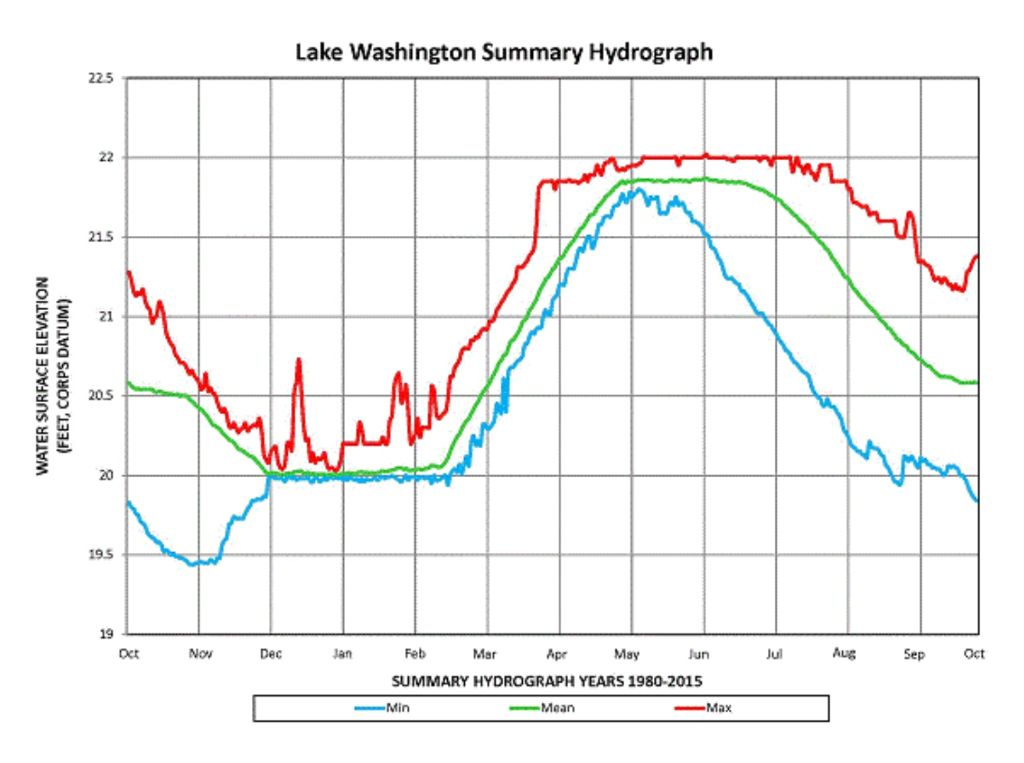
USACE typically maintains the water level between 20 and 22 feet as measured officially at the Hiram M. Chittenden Locks. Corps officials keep winter water levels at 20 feet, and begin the annual summer refill in February, targeting a 22-foot elevation by late May to early June. The higher level helps meet summer water use requirements, providing water necessary for fish passage, navigation, and salinity control. Water is slowly consumed throughout the summer, until it reaches the winter level typically in early December. While the lake is rising, vessel owners should closely monitor lake elevations and adjust mooring lines as necessary. Fill rates and target elevations vary through May based on conditions. The record low lake level is 18.35 feet, reached in 1958. The lowest recent recorded water level below 20 feet was 19.91 feet, measured in August 2015.
The 22-foot target elevation is referenced to the local project datum, equivalent to 18.75 feet referenced to the North American Vertical Datum of 1988. Lake Washington and Lake Union levels may vary due to natural gradient between the lake and the locks, or wind that can push the lake levels up for short durations. More information on Lake Washington’s status is available on the Corps’ Seattle District Reservoir Control Center website here.
Members of the FHA Board met with Logan Osgood-Zimmerman, Senior Water Manager with the Seattle District Corps of Engineers to better understand how the water level is managed by USACE. You can view her presentation below.
For more information about activities at the Locks, visit the Locks’ Web site here. Also, follow the Locks on Facebook here and Twitter here. The chart below shows the annual cycle.
More information on Lake Washington’s status is available on the Corps’ Seattle District Reservoir Control Center website at http://bit.ly/NWS-RCC.
 Ballard Locks Chittenden Locks drought Lake Washington Lake Washington Ship Canal U.S. Army Corps of Engineers